Mount Wilhelm (4,509m) and Giluwe (4,368m)
Written by Leader David Hamilton, September 2015
Mount Wilhelm (4,509m) and Giluwe (4,368m) - Reconnaissance trip report
At the end of the Jagged Globe Carstensz Pyramid expedition (report here) the team members flew home to the UK and I chose to spend a few extra weeks in the South Pacific region. I crossed from the western part of New Guinea to the eastern part of the island, travelling from the Indonesian province of Papua to the independent country of Papua New Guinea (PNG).
There are no direct flights from Indonesian Papua to PNG, so my journey from the Sudirman mountains of Papua to the Central Highlands of PNG required a complicated 9 day journey: flight from Timika to Jayapura, taxi to Indonesian frontier post at Skouw, walk across the border to the PNG frontier post at Wutung, taxi to Vanimo, flight to Madang, bus to Goroka, and bus to Mt Hagan. This gave me a chance to see something of PNG and learn a bit about this complex country which was administered by Australia until Independence in 1975. Apart from a narrow coastal strip most of the country is mountainous and densely forested. Of the 6 million population 85% are subsistence farmers, mostly living and working on steep hillsides. The main cash crops are coffee, coconuts and timber. Increasingly mining (copper and gold) and a new LNG gas field is transforming the national economy, but little of the income is reaching remote rural communities. Much of the health and education provision in rural areas is still in the hands of missionary organisations. The road network is poor: many coastal communities can only be reached by boat and many highland communities can only be reached by air.
I had arranged to meet Pym Mamindi at Mt Hagan (the name of PNG's third largest city as well as the mountain that towers over it). He is the owner of a small tourism business and had agreed to organise transport, accommodation and a local guide for me.
My first climb was Mt Hagan, a complex mountain with many ridges and many summits. Maps show the highest point to be 3,834m. There is a good path to the high ground starting in the gardens of Magic Mountain lodge at 2,490m. The trail climbs through forest to a height of 3,300m where the trees end and open grasslands begin. The path to the top follows an easy ridge line leading to an obvious summit at 3,815m with a radio transmitter tower. The highest point is about an hour further to the west. Round trip time from MM lodge is about 6-8 hrs, depending which summit is climbed.
Giluwe (4,368m), is the highest volcano in Oceania and one of the 'Volcanic Seven Summits'. It is not yet a commonly climbed peak and gets far fewer visitors than PNG's highest peak, Mount Wilhelm. The roadhead is a one hour drive from Magic Mountain and the peak can be climbed in two long days. The first day's hike climbs through the forest from Malke (2,600m) to leave the trees at 3,400m, in approx 3hrs. The rest of the hike is through grassland mostly following a ridge line. A high point of 3,900m is reached shortly before camp. A short descent leads to a good campsite in a small stand of trees at 3720m. Moving fairly quickly I took 7hrs from the roadhead. The next morning I started at 05.00 the and reached the summit before 07.00. The final 100m is a little steep, mostly on grass with some small rock outcrops. In the dry season (Aug / Sept) these do not present any problems. In the wet season this section might get quite slippery. The descent to camp took less than an hour where I enjoyed a decent breakfast before the 6hr hike back to Malke, giving a 9hr day.
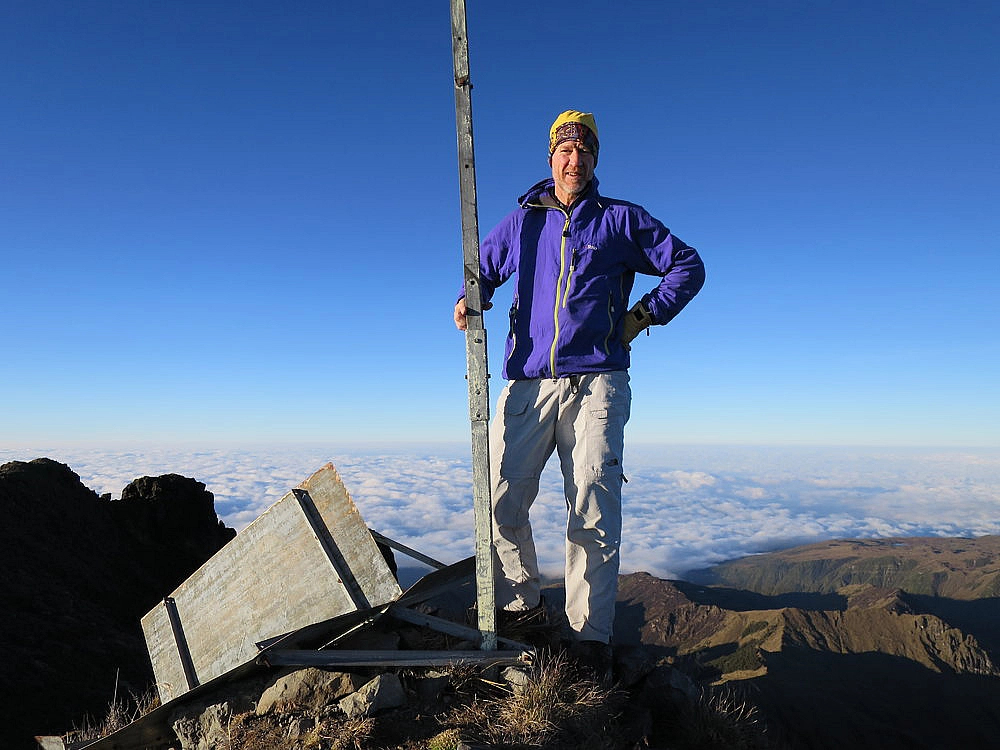
I took a local bus from Mt Hagan to Kundiawa along the highlands highway and then transferred to another bus for the trip up a minor road to Kegsugl, a total journey time of 4hrs. Kegsugl is the starting point for climbs of Mount Wilhelm (4,509m), the highest point in PNG. It is normal to climb the peak in two days from Kegsugl (2,800m). The first day's hike to the ANU huts (3,575m) located by the lower of two lakes is short and easy. A well-maintained trail leaves the village and climbs through the forest to 3,200m where the landscape changes into open moorland. I took a bit less than 2hrs for the 5.75km hike to the hut. The interior is basic, but had new (clean!) mattresses and pillows which perhaps justified the £20 hut use fee. There is a twin burner gas ring and pots, as well as cups and plates. First light on the summit is a little before 06.00, and it not uncommon for the clouds to start building by 07.00, so climbs need to be carefully timed. My guide wanted to start at 1.30 assuming we would take 5hrs to reach the top. I persuaded him to leave at 02.30 and we got to the top at 05.25, a climb of 2hrs 55mins. It was dark on top and quite cold so I took some pictures of the summit marker post using my camera flash and set off down before first light.
The trail from the hut to the summit is fairly obvious in daylight, however could be harder to follow in dark or misty conditions. Leaving the hut the trail goes round the left side of the first lake, and climbs 100m to reach the level of the second lake. The trail turns left (south west) and climbs until approx 4,000m. It is mostly a stony path up a grassy hillside. Around 4,000m the trail turns to the right (north) and traverses the hillside. This rightwards traverse line continues for some distance and goes almost as far as the summit. At 4,100m a small col is reached. This is not crossed, the rightwards traverse continues. Several false summits can be seen looming out of the dark on the left. Ignore them all and keep following the obvious traverse line. In the last few hundred metres before the summit there are several white paint marks on the rocks to show the way. There is a transmitter tower on the final 'false' summit, but the route does not go near it. Finally, 100m horizontal distance and 50m vertical distance before the true top the path reaches the ridge crest and crosses to the other side. The route to the top is obvious and involves a little rock scrambling, which is perhaps best done in daylight. From the hut to the top is a distance of 6km. I was back in Kegsugl by 10.00.
Rather than head back South to join the highlands highway I decided to trek north to the coastal lowlands, following a trail from Simbu Province to Madang Province. This was a straightforward trek along sections that could have been driven with ease, sections that could be driven with difficulty and sections that must be walked. The road from Kegsugl to Snow Pass has recently been improved, but there is no way of knowing if it will survive the next rainy season. The road leaves the bridge at lower Kegsugl (2,650m) and climbs to a pass at 2,950m. This marks the border between the two provinces. From here the road passes two small settlements as it descends to Snow Pass (2,130m), a distance of 26km from Kegsugl (7-8 hrs). There is a one room guesthouse on the outskirts of town called Mari Mari. Snow Pass to Bundi is about 16km and can be walked in 4-5 hrs. The 'new' road ends soon after Snow Pass and the trail becomes narrower, but is still passable by jeeps. At the start of Bundi (1,420m) the road splits. The 'new' jeep road takes the left fork and loses height quickly. The old road on the right passes through the market area and becomes a single track walking trail which offers a more challenging 6hr/20km route to Bramin (250m) in the broad valley of the Ramu river. It is a 2-3 drive from Bramin to the junction with the Madang - Lae highway, and a further 2hrs to Madang.
For me this turned out to be an exotic travel trip with long bus rides, lots of waiting around and some mountaineering. However with prior knowledge of PNG plus prearranged local transport it will be possible to organise a trip that maximises the climbing and trekking and keeps the waiting and travel times to a minimum. I made many friends who are trying to develop tourism businesses in PNG (Pym in Mt Hagen, Betty in Kegsugl, Diane in Madang). I hope to see them all next year when I return to the country leading the first Jagged Globe group to PNG.
David Hamilton 9th September 2015. Complied at various points during the trip and completed in Jayapura.
Please note the above report and itinerary on the Jagged Globe website is copyrighted.
« Previous report | Next report »
Categories
- Announcements (0)
- Blogs (0)
- News (0)
- Trip Reports (0)
- Articles (0)
Archives
- May 2026
- April 2026
- March 2026
- February 2026
- January 2026
- December 2025
- November 2025
- October 2025
- September 2025
- August 2025
- July 2025
- June 2025


