Lungser Kangri - 29th Jul - 18th Aug '12
Written by Leader Neal Short, September 2012
As an expedition we successfully climbed our main goal, Lungser Kangri (6662m) but achieved much more too with the trek passing through tremendous cultural and physical landscapes.
The team, Will & Jo, John and Louis convened at the plush Claridges Hotel in Delhi. Our stay was brief but we managed to take the opportunity to visit Indias largest mosque the Jama Masjid, pass by the impressive Red Fort in a rickshaw and have a wander around Connaught Place. (On our return to Delhi we also visited the bustling Chandni Chowk which is in the old market district of Delhi).
As with flying to the mountains in Nepal, the Leh flight is something of a treat in itself - though without the Lukla landing. The early morning flight gave splendid views which became increasingly more arid and of snow-capped peaks (out of left side of plane). The spiralling descent down into the broad Indus Valley afforded great views of the Stok Kangri massif and of the numerous spots of lush green oasiss of life. The flight brought stark changes; from the stifling humidity of Delhi to the dry climate of Leh and as soon as we were out of the airport we noticed the cultural shift in the peoples of this region and the obvious religious change from Hinduism to Buddhism.
We arrived at our hotel for a breakfast and then had a brief nap. Although we had only just flown into 3500m we all felt ok to do some sight-seeing. We decided to take a slow wander up to the Japanese Stupa which afforded terrific views out across the city. Along the way we had a coffee on the roof terrace of Café Jeevan. The following day the team opted to book a jeep for a half day tour to the small but artistically impressive and important 11th century temples at Alchi.
To get to the start of our trek, we took a 2hr jeep journey initially along the Leh - Srinagar highway. The road, mostly high above the mighty Indus river, went past a number of military barracks which emphasised the, at times, tense political border situation that exists in this region. Upon turning left at the confluence of the Indus and Zanskar rivers we wound our way up a surprisingly, mostly metalled, single road to the box and cable bridge near Chilling. By now it was very hot in the midday sun and we sought shade in a temporary Tea Tent (basic café shelter). After waiting our turn, we crossed in the box in pairs - firstly whizzing out to a stop in the middle of the cable above the fast flowing Zanskar river and then to be pulled in the other side by our trek staff. Soon after, we started up the trail whilst our trek staff sorted the loads for the horses.
We had the pleasure of being on the expedition with an excellent in-country trek team whom were mostly Sherpas from Darjeeling - the incredibly gifted and much appreciated cook Nima; two very strong and hard-working climbing sherpas, Karma & Dawa; Dinesh the assistant cook who always did more than his specific job and the camp helper of Gungaran. Our sirdar Norbu was from the Makalu region in Nepal and Tinjeen, a camp helper, was a young local man from near Thikse. Lastly our horseman was a jolly chap called Tashi who was always first with jule (pronounced jullay; a general greeting word).
The 3hr walk up to camp at Skiu (3340m) was a hot one with intense sunlight. It was definitely best to cover up and we realised why it is important to wear a wide brimmed hat, lightly coloured trek clothing- in particular a long sleeved shirt and of course, good quality sunglasses. At Skiu the staff pitched our tents on a small section of grass and quickly readied the mess tent to serve drinks and biscuits. As during the rest of the expedition, the time before our evening meal gave us a chance to rest, get some washing water and explore the surroundings. Most impressive here was the Skiu monastery which was perched on a rock promontory straight across from camp and behind us, there just happened to be the ruins of a 1000 year old royal residence! Tonight was the first of the brilliant food from Nima, he surpassed expectations each meal time with the flavours, variety and presentation of his food. Coming out of the mess tent that evening we were full with food, buoyed by starting the expedition proper and then had the fine sight of a full-moon rise which illuminated the monastery and cast shadows on the mountains.
We started the following day at 7.10am for the fairly long trek up to Markha (3800m). It was another hot day however we had a suitable pace to compensate and drank sufficient fluids. The small well irrigated settlements, mani stones/walls and chortens that we passed en-route made for fascinating viewing. Just after 3pm we made our first river crossing (a number of braided channels) and reached camp shortly after sandals being absolutely mandatory. (The heat had probably accounted for the extra hour beyond the suggested itinerary time indeed last year's team did the walk in 7hrs).
The next day we again left camp around 7am. On the initial part we had a few river crossings to negotiate; firstly an open braided section and then soon after a deeper single channel where the valley had narrowed. The team put their sandals on, rolled up there trousers and took the crossings in their stride. The rest of the route took us past many more mani walls, chortens, a ruined fort and the through tiny settlements trying to make the most of the short farming season. We had lunch inside a classic Ladakhi house in Lower Hankar and then trekked past the ruined Hankar gompa to reach Higher Hankar.
Shortly after these settlements we turned off the main trekking trail and headed up the much less travelled Langtang Chu valley. Just before reaching camp we needed to cross a rickety bridge and then make a small river crossing. The campsite was at a large grassy plain with impressive views of the pyramidal peak, Kang Yatse (6400m). We took 7hrs 30 - with stops and time for a good lunch. Another incredible day trekking in the Land of the Gompas.
By now we were all into the swing of things with the daily schedule and had coped well with our first night camping at over 4000m. The weather had become a little overcast. I had enjoyed the time on the main trail, occasionally meeting other trekking groups who were going over to Nimaling, though it now felt great to be striking up a remote valley. The trails had narrowed and there were to be no settlements for a couple of days. We were now very much in splendid rugged isolation.
The route we were following is sometimes used by monks to visit the gompa at Dat. Our aim for today was to get to a camp beneath our big pass, the Zalung Karpo La (5197m). We crossed a number of small river channels before stopping for our mid-morning snack (pancakes & honey) at the delightful grassy pasture (4280m). Here we spotted bharal (Blue sheep) on the rocky hillsides and ridges. Further on we passed mani walls at Tamachan (4400m) and we zigzagged our way around the large interlocking spurs caused by the rivers constant erosion. Just when we were starting to feel the altitude our camp appeared out of the blue as it had initially been obscured by a large lateral moraine. We took 6hrs 30mins to get to the camp at Yakrupal (4670m).
The big trekking day arrived with everyone in good health and we left camp at 8am. We had slow measured pace and reached the fluttering prayer flags on the broad-rounded pass in 4hrs.
Magnificent views stretched afar; out across the glaciated Kang Yatse range to the east, west across umpteen lesser but shapely peaks of the Zanskar range and our route south down the valley to ultimately access the settlement of Dat and our jeep journey to Tso Moriri.
The initial descent from the pass proved to be swift and also surprisingly dusty - a Buff over the mouth gave welcomed relief. Soon enough though, we were on usual trails and approaching a good spot for lunch which once again, even in this situation, was incredibly served on a plate with a knife & fork. We arrived in camp (4375m) at 3.30pm.
This final day's trekking was longer than the rest but memorable and rewarding - the day just kept on giving. We initially wandered down past the deserted tiny settlement of Sorra (everyone was away at summer grazing pastures). Then we entered a dramatic and beautiful canyon. We marvelled at the high yellow & orange rock walls and considered the size of the river that must have formed it. A team member from the 2011 trip mentioned in her report that the canyon was one of the most beautiful places I have ever visited.
An hour or so later, the canyon opened up into a broad confluence (4050m) where we turned left (upstream) and enjoyed a refreshing easy river crossing in the midday sun. The next section reminded me of the Todra gorge in Morocco. This time the canyon was even narrower and had pockets of willow growing alongside the river which allowed for periods of shade. Eventually the route emerged into a wider valley but still with spectacular huge towering walls like Tre Cima in the Dolomites. Since lunch we had been making a gradual ascent to Dat (4320m) and we got there after a two small moraine-like rises decorated on top with long ancient mani walls. Camp was situated just beyond Dat on a large pasture and in total we took 7hrs 50mins for the day. The weather broke and we had rain overnight.
Before we got to our mountain we had a splendidly scenic journey to the wild west settlement of Korzok. Firstly, we went over the Yar La (4957m) and then on down to briefly join the Leh Manali highway where we had lunch before carrying onwards, in quite heavy downpours, over numerous other high passes.
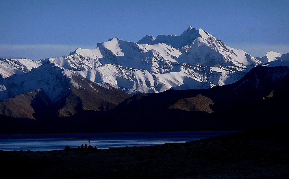
The landscape changed becoming more rolling and expansive; and the settlements much larger such as Puga and Sumdo. The absorbing drive also took us past a number of lakes; the salt lake of Tso Kar and then freshwater lakes of Startsabuk Tso and Thatsang Tso. Clearly we were on roads, occasionally metalled, which if trekking in the area must detract from the experience in comparison to the trek we had just completed. We camped up the valley behind Korzok, the main settlement on the shores of the massive Tso Moriri. In the morning we followed the advice of JGs Mungo Ross to go further up the valley to visit the Changspa people at their summer grazing encampments. We wandered at a respectful distance past their yak wool tents but still managed to catch glimpse of their simple and hard way of life. Before finally getting going to Lungser Kangri we took the chance to look inside the Korzok monastery and walk around the chortens.
The drive round the northern tip of Tso Moriri to base camp (4780m) just above Skyurchu, took less than two hours. We arrived at 1pm, having decided as a team to get to BC so that we could unpack and rest during the afternoon. The Sherpa team had gone ahead that morning so we arrived to BC all set up.
Now started the process of switching from constant trekking into a slower expedition peak mode. Our next camp, ABC, was at 5680m so we had to have an acclimatisation day walk from BC. Above BC, a ridge extended towards Chamser Kangri (6600m) and this proved useful to gain height. We climbed past a number of small cairns and soaring Kestrels to reach a suitable high point of 5460m before descending in time for lunch and an afternoon's rest.
The following day was a good hike as we made our way from BC to ABC. All the kit was transported on horses. En-route we went past a small herd of Kiang (Tibetan wild horse-like ass) and across high open slopes which had a number of different flowering pioneer plants. After a few testing ridges we got to camp in total of 7-8hrs. It was always going to be a tough day moving to ABC considering the altitude and height gain but one that was to be rewarded with a full rest day afterwards.
It was pleasing to see the team had made the transition to the new height without any AMS problems and we all enjoyed a leisurely rest day, though myself and Louis did take a short wander just above camp to 5800m. The Sherpa staff now started carrying loads to Camp 1 (6242m) which was situated on the col between Lungser and Chamser. ABC was comfortable with good flat camping spots and with the sun striking the tents soon after bed-tea at 7am.
In agreement with the team we decided to give ourselves the possibility of another day on the mountain to aid either further acclimatisation or an extra summit bid. This was made possible by descending from ABC to BC and then straight onwards to Leh instead of that happening over two days. This proved to be an excellent option and the journey out at the end wasnt considerably different in time to what it should have been as per the itinerary.
Once again, like at BC, the best approach for our team was to have a suitably paced acclimatisation walk above ABC. This time we followed the easy angled terrain towards C1 and gained a high point of 5950m before getting back to camp for 1pm (total time, with numerous rests, 4hrs). This proved to be a personal best for both Will and Jo.
We had been having the occasional shower during our time on the mountain and we awoke on the morning of Expedition Day 17 to a few cms of snow. That morning Will who had been suffering from a dry cough and Jo decided not to make a summit bid and the previous evening, John expressed that he felt happy with what he had achieved so far so also wasnt going to move up to C1. Therefore myself, Louis and three Sherpa staff moved up the C1 whilst the other team members, accompanied by the Sirdar Norbu, descended to BC. It only took us 4hrs up to C1 and cloud covered most of the Lungser and Chamser summits when we arrived. We all had lunch in the main tent before myself and Louis turned in to our tent for some rest. The evening meal was kindly served to us in our tent and then we settled down for the alarm at 3.30am.
We awoke to a partially starry sky and a fresh dusting of snow. We had done well throughout the night in terms of the altitude which proved the value of our initial considered acclimatisation regime. We started out at 4.30am.
By sunrise we were well established putting in fresh tracks on the traverse towards the upper slopes of Lungser. Initially we got some views out east (towards Tibet) before ending up misty cloud and flurries of light snow.
It was only a 450m summit day but nevertheless it was challenging due the snow conditions. All the while during summit day we took GPS waypoints to help our navigation. We headed upwards on the final shallow angled slopes for about 45 minutes until eventually seeing the summit prayer flags and soon after stood on the summit at 11am.
I was pleased for Louis who had shown determination to focus on our goal that morning and probably made the first South African ascent as well. Also we felt joy in sharing the moment with our likeable and capable sherpas, Karma and Dawa. We spent around 25 minutes on the top of Lungser Kangri (6662m) and then descended quickly to C1 in not much over an hour. Our descent time proves that ordinarily an ascent time could be around 5hrs and not our 6hrs 30mins. (Indeed a few weeks earlier in normal conditions, well-known JG leaders, John Eames and Bonny Massam had a personal 4hr 30mins summit day ascent). After some welcomed lunch at C1 we headed to ABC, taking just over 2hrs. As planned the horseman had arrived in camp for the following mornings descent to BC and the jeep out back to Leh. The walk down to BC, with splendid views across the lake to Korzok and the Mentok range only took 3hrs.
Once again the driving stage proved another highlight, being mostly in deep valleys and along the Indus river as it relentlessly flowed through areas of outstanding stark beauty and past gompas galore in particular at Thikse and Shey. Also we had the Ladakhi road signs to keep our driver concentrating and cause some amusement for ourselves such as; After Whiskey Driving Risky, Be Gentle On My Curves & Don't Be A Gama In The Land Of Lama (I later found out that Gama was a well-known wrestling champion).
As always on such expeditions we owed a lot to our friendly and hard-working in-country staff. We all personally thanked them and gave tips on our last evening in Leh.
The following morning's flight back to Delhi was once again an early one (5.40am) though this at least gave us plenty of time to fully enjoy the luxurious Claridges Hotel and go into old Delhi.
To sum up; thanks must go to the team members and in-country staff for their great company. It was a rewarding expedition due to cultural aspects, the trekking amongst the jagged peaks of the Markha Valley & the outstanding isolated canyons beyond; and the opportunity to climb a high non-technical mountain in the starkly beautiful Rupshu region.
Neal Short, Leader.
Furthering reading: The first ascent report in the Himalayan Journal (by a slightly different route) - www.himalayanclub.org/journal/nangpas-are-flying-changpas-are-smiling/
Maps of the area: Available online at Stanfords or Amazon.
For the trek: Ladakh & Zanskar Central 1:150,000 Indus, Zanskar, Pangong.
For Lungser Kangri: Ladakh & Zanskar South 1:150,000 upper Zanskar, Rupshu.
Categories
- Announcements (0)
- Blogs (0)
- News (0)
- Trip Reports (0)
- Articles (0)
Archives
- July 2026
- June 2026
- May 2026
- April 2026
- March 2026
- February 2026
- January 2026
- December 2025
- November 2025
- October 2025
- September 2025
- August 2025


